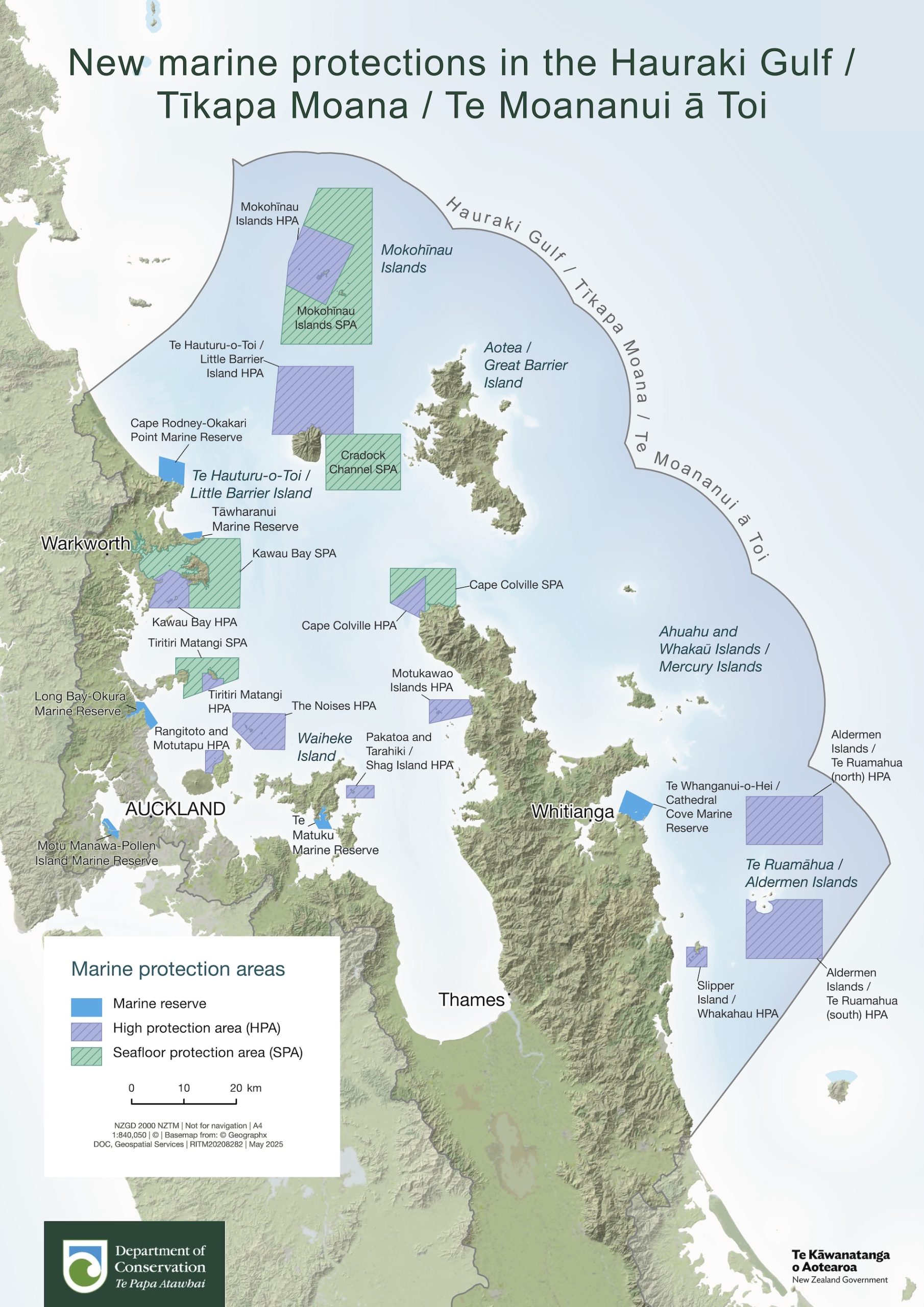
New marine protection areas come into force across the Hauraki Gulf this weekend, as part of the Government’s new Marine Protection Bill — marking one of the most significant shifts in local fishing rules in decades.
From Saturday 25 October, 19 new protected zones will take effect, covering parts of the wider Gulf including areas east of the Coromandel Peninsula. The Department of Conservation (DOC) will manage and monitor the new network, which includes ‘High Protection Areas’ and ‘Seafloor Protection Areas’.

DOC’s Marine Operations Manager, Kirsty Prior, says the department’s focus this summer is on helping people understand where the new boundaries lie and what they mean.
“We’ve got a new team of marine rangers, community rangers and a bunch of seasonal staff gearing up for summer. We’ll be heading to events, boat clubs, boat ramps and out on the water to chat about these new marine protections,” says Kirsty.
“We understand this is a big change for many in the fishing community, and we’ll be working alongside you as everyone gets familiar with the new boundaries and what they mean.
“This law is brand new. It will take time for the practical changes to take place – such as updates to electronic chart-plotting systems and installing physical markers.
“These protections are very important. They will take some pressure off crucial underwater habitats such as productive reefs and sensitive sea floors. We’re giving space for marine life to thrive, and over time this will help contribute to a healthier gulf with more fish for everyone.”

DOC’s marine and support teams will be based in Whitianga, Warkworth, Auckland’s North Shore and the CBD. Their work includes educating fishers, installing new signage, and monitoring the impact of the protections on marine habitats.
“Currently the team is working to install signage at boat ramps and entry points, distributing protection area maps to local businesses such as fishing retailers, updating the DOC website, and have provided maps to chart-plotter providers to update their mapping systems,” says Kirsty.
“We expect updates to digital charts to happen when these manufacturers are able. The installation of signs and marker buoys will roll out progressively over summer and into early 2026. Fishers can find the latest maps and updates at www.doc.govt.nz/haurakigulfmarinepark.
“Our focus for now is on education and support. Compliance activity will gradually increase as people become more familiar with the new protections. This will include both on-the-water patrols and the use of drones and high zoom CCTV cameras to monitor activity in these protection areas.”
While DOC says 94 percent of the Gulf remains open for recreational fishing, the new restrictions will limit where and how people can fish in the most sensitive areas.
“We’ve had questions about what the new protections mean for recreational fishers, and for customary fishing. Here’s a quick guide to clear things up,” says Kirsty. “While some areas now have higher protection, the majority of the Gulf remains open for recreational fishing.”
High Protection Areas ban recreational and commercial fishing, with limited commercial ring-net fishing permitted in only two of the twelve HPAs for six months of the year, largely over winter. That allowance will be reviewed after three years.
Māori non-commercial fishing is still allowed in High Protection Areas with written authorisation from a tangata kaitiaki for a customary purpose such as a hui or tangi.
Seafloor Protection Areas ban bottom-trawling and dredging but still allow low-impact methods such as line fishing and diving for seafood.